Planning commission recommends approval of Upper Westside Specific Plan.


The Sacramento County Planning Commission voted Monday night to recommend approval of the Upper Westside Specific Plan, advancing a project that could reshape a large swath of Natomas farmland into a dense, mixed-use community along the edge of the Sacramento River.
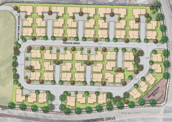
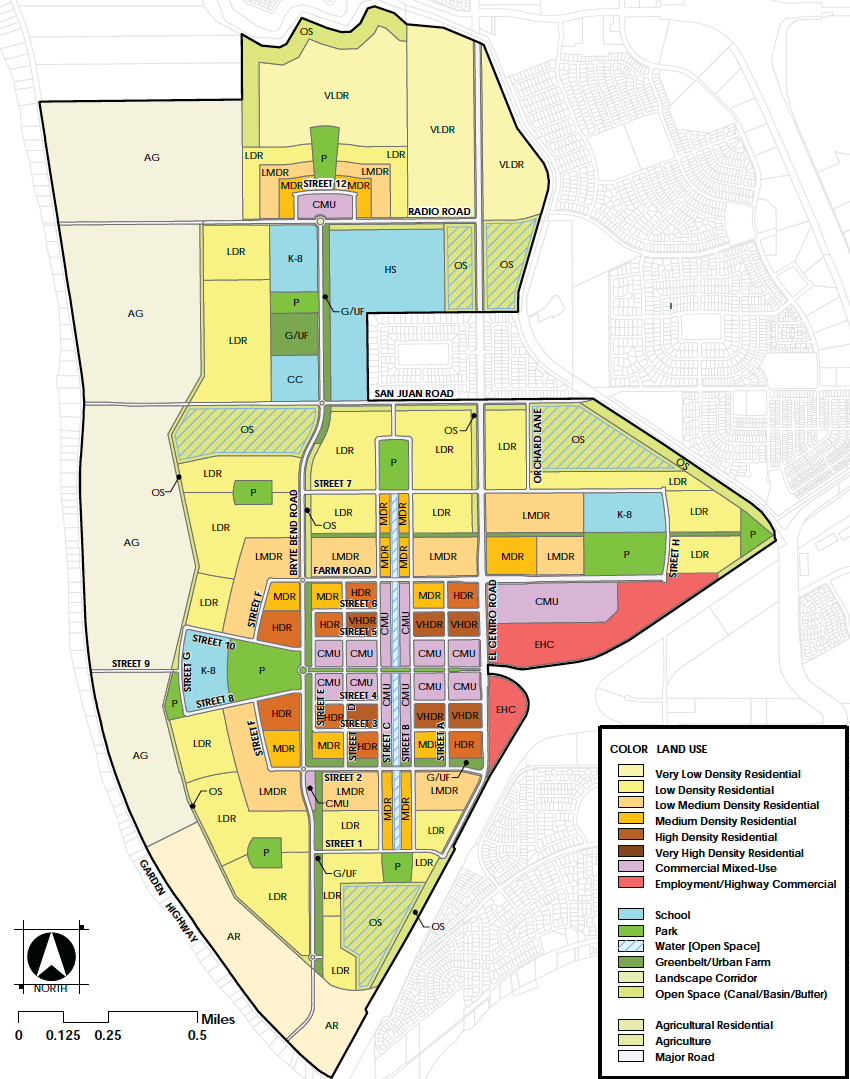
The 2,066-acre proposal—which includes 9,356 homes, a town center, trails, schools, and preserved agricultural buffers—has been in motion for more than two decades. The vote followed a four-hour public hearing and more than 11,000 pages of environmental, planning, and financial documentation.
Commissioners forwarded the project to the Board of Supervisors with a recommendation for full approval, including certification of the Final Environmental Impact Report, several General Plan amendments, a development agreement, and key supporting documents such as the affordable housing strategy, water supply assessment, and urban services plan.
“This project has been in the making for over two decades,” said Emma Patten, the senior planner presenting the plan. “Planning efforts began in 2002 with the Natomas Joint Vision Memorandum of Understanding between the County and the City of Sacramento, aimed at guiding future growth, revenue sharing, and open space preservation in Natomas.”
Though the Joint Vision originally envisioned the City of Sacramento taking the lead on urbanization, the city’s decision not to pursue additional development in the area prompted Sacramento County to assume responsibility, particularly as private landowners began pushing for action. A series of community workshops and long-range land use studies followed, and in 2018, the county formally initiated the Upper Westside planning process.
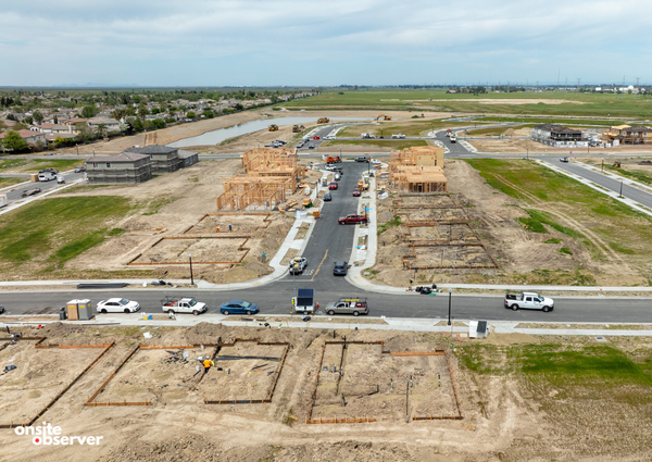
The project site lies just 3.5 miles from downtown Sacramento, bounded by I-80 to the south, Garden Highway to the west, Fisherman’s Lake Slough to the north, and the West Drainage Canal to the east. Much of the land is currently agricultural, with scattered rural homes and limited commercial development near El Centro Road and West El Camino Avenue. According to Patten, access to the site will primarily come via I-80, as well as El Centro and San Juan Road.
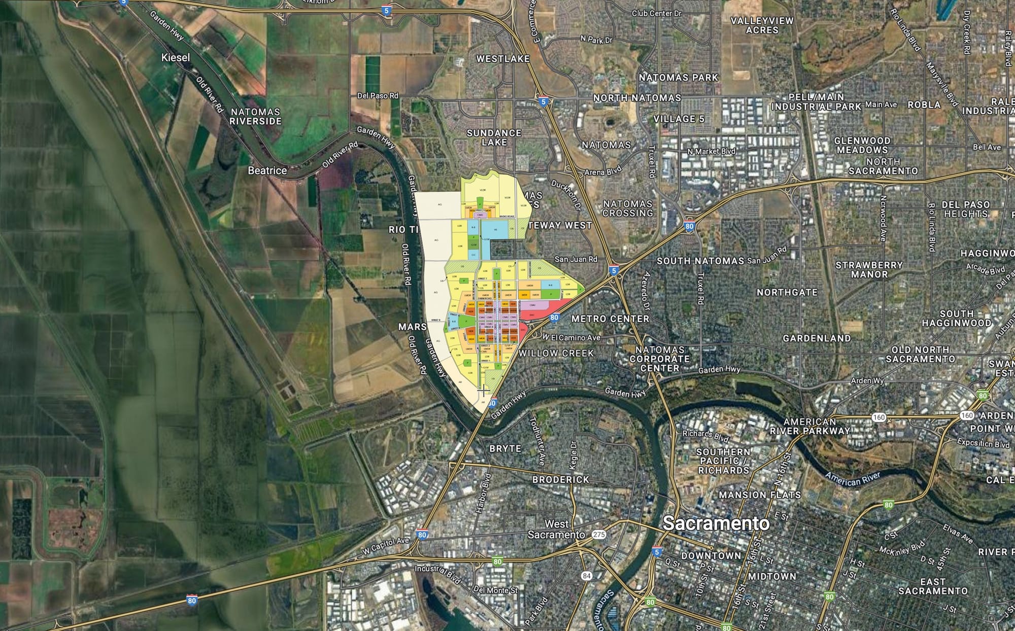
The vision for the area includes a network of greenbelts, a linear canal system running through the town center, and an “educational node” in the plan’s northern portion. While the full plan area spans 2,066 acres, only 1,524 acres are designated for development. The remaining 542 acres—mostly along the western edge—will remain as an agricultural buffer and are not proposed for urban zoning or annexation into the county’s Urban Policy Area.
Throughout the evening, commissioners raised questions about the plan’s technical aspects, including affordable housing obligations, habitat mitigation, transportation infrastructure, and the sequencing of development phases.
Commissioner Devlin asked about long-term traffic impacts on Garden Highway. County transportation staff confirmed that projected traffic volumes would exceed 6,000 daily trips at buildout by 2040, triggering the need for shoulder widening and upgrades to meet county collector road standards. “It wouldn’t be done in the existing plus project condition,” said Gary Gaspar from the Department of Transportation. “The mitigation would be more of a cumulative impact… seen at buildout in the year 2040.”
Patten also outlined the affordable housing strategy. “The property owners who collectively control about 20% of the planned area would fulfill their affordable housing obligation through land application,” she said. “Per county ordinance, they are required to dedicate 4.96 acres, but their strategy exceeds this requirement by offering a 6.9-acre site.”
Commissioner Sabeniano asked how many affordable units that might yield. Patten responded that the minimum density for the site would be 20 units per acre, with potential for up to 30 depending on the layout. The housing itself would not be built by the applicants but rather by a third party. “The site would be dedicated to SHRA,” she said, referring to the Sacramento Housing and Redevelopment Agency.
Several commissioners also asked about when the rest of the project might be built. While the current application only includes the "phase one" property owners—who control roughly 20% of the development area—future phases would be brought forward by other landowners over time. “Not necessarily [right away],” Patten said. “But the applicants may be able to speak more to the phasing of the plan and the ultimate timing of development.”
The environmental review process, which began in 2020, concluded with the publication of a Final Environmental Impact Report. That document identified significant and unavoidable impacts in areas such as air quality, aesthetics, agricultural resources, noise, transportation, and tribal cultural resources. In order to comply with the county’s 2024 Climate Action Plan, the project will be required to purchase verified carbon offsets in addition to implementing on-site mitigation.
Despite the environmental trade-offs, planning staff said the project meets all the performance criteria required under the county’s growth management policies—scoring a full 24 out of 24 points on factors such as housing variety, transit access, minimum density, and proximity to jobs.
In closing, Patten highlighted the project’s strategic location and its potential to deliver on the county’s long-term smart growth goals. “The site is just four miles from the State Capitol and regional job centers, making it a prime location for large-scale, mixed-use community,” she said. “The plan includes over 9,300 homes ranging from very low to very high density… and the project is expected to support nearly 14,000 jobs, resulting in a strong 0.95 to 1 job-to-housing ratio.”
The commission ultimately voted to recommend approval, but not without reflecting on the complexity and the years of effort behind the plan.
“11,000 pages of documents—it’s no joke,” said Vice Chair Borja. “I appreciate the effort that was put in by the team, the consultants, the applicants, and also the hundreds and thousands of pages of comment letters.”
The project now heads to the Sacramento County Board of Supervisors, which is expected to consider final approval later this summer.